When designed properly, Marine protected areas (MPAs) are one of the best tools available to protect key marine species and habitats, and help address the global biodiversity and climate crises. As part of marine planning processes, marine protected areas can provide a strong conservation foundation for a sustainable ocean economy.
Canada, along with 195 other countries, has committed to protecting 30 per cent of its lands and oceans by 2030, signing on to the Kunming-Montreal Global Biodiversity Framework. After exceeding its initial commitment to protect 10 per cent of coastal and marine waters by 2020 (reaching 13.81 per cent by 2020), Canada has also laid out a pathway to 25 per cent ocean protection by 2025. As of January 2025, about 15 per cent of Canada’s ocean is legally protected.
Despite the progress made in recent years, roadblocks remain along the path to 2030. For example, while Canada announced minimum protection standards for federal MPAs in 2019, which will keep four harmful industrial activities out of new federal MPAs (oil and gas, bottom trawl fishing, mining and dumping), these standards have yet to be fully implemented. Some protected areas that are already established do not have the level of biodiversity protection required to meet international standards. The Ecology Action Centre works with a diverse array of partners from the local to international level to advocate strongly for progress on protected area establishment and for improvements in the quality of protection offered. We work to ensure that coastal communities and sustainable ocean livelihoods can continue to grow and thrive alongside ocean protections that play a critical role in halting and reversing biodiversity loss in our ocean.
Community-led Marine Planning in Gros Morne, Western Newfoundland
Community-led Marine Planning in Gros Morne, Western Newfoundland
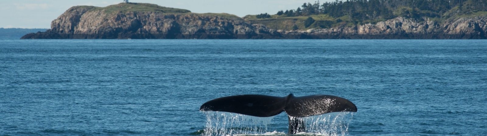
In many parts of Newfoundland and Labrador, communities are defined by a relationship with the land and water. Our understanding of the ocean has grown over millennia from the knowledge shared by the Mi’kmaq and Beothuk People to the traditional ecological knowledge passed down over the centuries by fish harvesters who have lived and worked in the ocean surrounding this region. Nowhere is this truer than the Gros Morne region of western Newfoundland, where a rich mosaic of landscapes, seascapes, terrestrial and marine ecosystems offer sustenance, livelihood, independence and so much more. The area in and around Gros Morne National Park, and its neighbouring coastal communities, is one of the most amazing spots in Atlantic Canada to explore pristine rivers and glacially carved fjords, as well as bays and harbours teeming with marine life.
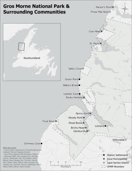
 The Gros Morne region and its surrounding communities including historic settlements, local municipalities and service districts along western Newfoundland. The Gros Morne region is made up of seven enclave communities within and surrounding Gros Morne National Park: Cow Head, St. Paul’s, Rocky Harbour, Norris Point, Glenburnie-Birchy Head-Shoal Brook, Woody Point and Trout River.
Since 2020, EAC has been on the ground working with communities in the region to build the Gros Morne Community-led Marine Atlas. More than just a book of maps, the atlas tells the story of the people of Gros Morne, their connection to the sea and highlights more than 50 years of local ocean science, offering a tool towards the future development of a community-led marine plan for the region.
The base of this atlas was built using the biological and social science research conducted since 1967 at Memorial’s Bonne Bay Aquarium and Research Station and the economic and social surveys and marine mapping work undertaken by EAC’s project lead Rebecca Brushett for her graduate thesis. With a wealth of base information to guide this project, the EAC hosted engagement sessions with over 400 participants who generously donated their time, knowledge and expertise to surveys, participant mapping exercises, advisory committees and discussions of values, visions and concerns for the region. We engaged with Indigenous First Nations, local fish harvesters, academic experts, business owners, tourism operators, town councils and community organizations throughout the region. Stakeholders and rightsholders identified areas most important to them as it relates to fisheries, tourism, culture, activities, future economic opportunities and potential marine protection.
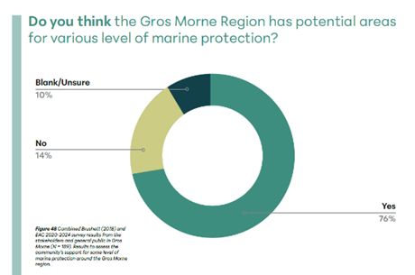
 Incorporating environmental values from society in a meaningful way is essential for the success of marine protection initiatives. Bringing some of the waters surrounding the Gros Morne region under some level of protected status would create one of the only “land and sea” connected sites in Atlantic Canada. As the engagement process developed in the community, EAC observed an increasing openness to certain types of marine protection over time with surveys showing 76 per cent support for some level of marine protection. EAC felt the key reason for this shift was consistent two-way knowledge sharing.
This atlas is designed to be updated, ideally, every five years as more research is conducted. The atlas is not only something for the people of Gros Morne but it’s also a tool for planners and decision-makers to use when making decisions that relate to the future health and use of our ocean.
If you want to learn more about building a marine plan for your region, or if you are interested in the data used to produce the maps and other content in this atlas, contact us!
People, Place & the Ocean podcast
People, Place & the Ocean podcast
We're excited to launch People, Place and the Ocean, a new podcast that dives deep into the stories, science and history of stewardship that has shaped the coastal area of Gros Morne in Western Newfoundland.
This show is bringing the Gros Morne Community-led Marine Atlas to life. Get ready to learn stories from the local people and hear their reflections on critical topics such as national parks, stewardship, blue economies, conservation biology, interdisciplinary research and economic development. Each episode features guests including fish harvesters, tour operators, scientists, Indigenous community members and those that helped the creation of the Marine Atlas. Follow along as we develop a deeper appreciation for the value our coastal and marine environment brings to this community!
Click the icons below to listen on Spotify or YouTube:


Eastern Canyons Marine Refuge
Eastern Canyons Marine Refuge
We’re excited that Fisheries and Oceans Canada has now formally established the Eastern Canyons Marine Refuge. This fisheries closure, established in June 2022 and located roughly 230 km offshore of Nova Scotia, east of the Sable Island Gully, will protect fragile deep-sea corals and associated ocean life (fish, sea stars, anemones, and crustaceans) from bottom fishing for generations to come. We have advocated for the establishment of this site for many years and were part of the technical advisory group that worked on site design, along with fisheries managers and industry and conservation organizations
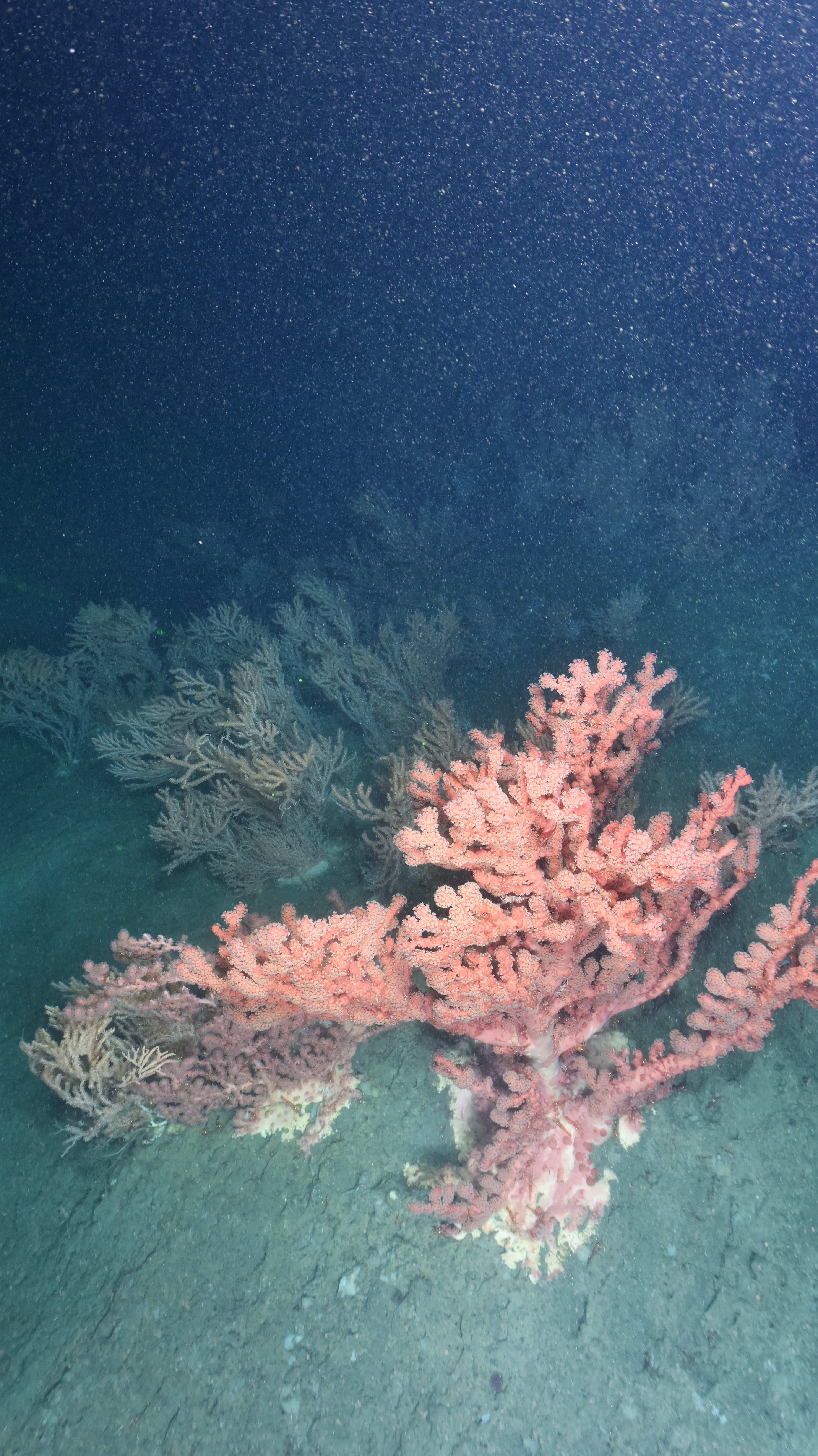
Cold-water corals like this one create sea-bottom habitat that is vital for many fish and invertebrate species; these corals are also extremely sensitive to disturbance so require protection from damaging fishing practices
At nearly 44,000 km2, Eastern Canyons Marine Refuge becomes one of the largest protected marine areas in Atlantic Canada. It includes parts of the Scotian shelf and slope, two deep-sea canyons with an incredible diversity of marine life, and a large area of deep-sea plains further offshore.
The refuge includes an increased area of protection around the only known mounds of reef-building spider corals (Lophelia pertusa) in Atlantic Canada, which had been severely damaged by bottom fishing impacts. Research by Fisheries and Oceans Canada at this location has shown that protection can help these reefs gradually recover from damage, although this process may take decades.
Eastern Canyons Marine Refuge is also home to dense patches of vibrant soft corals and many species that associate with them. By eliminating the impacts of bottom fishing in this area, the Eastern Canyons Marine Refuge will help preserve biodiversity and make Atlantic Canadian deep-sea ecosystems as resilient as possible.
We are happy to have worked with Fisheries and Oceans Canada and other partners through a collaborative process to establish this site and help improve the health of our oceans.
Fundian Channel-Browns Bank Area of Interest
Fundian Channel-Browns Bank Area of Interest
The Fundian Channel-Browns Bank Area of Interest (AOI) is a proposed MPA located approximately 135 km offshore of southwest Nova Scotia. The Fundian Channel is a wide submarine channel that separates Georges Bank to the southwest and Browns Bank to the northeast. The AOI includes a range of important and sensitive habitats and species. For example, at the mouth of the channel, where the waters of the Bay of Fundy drain into the Gulf of Maine, there are dense aggregations of cold-water corals and sponges which create habitat for all kinds of deep-water fish and invertebrates. The Browns Bank portion of the AOI provides habitat for dense sponge aggregations and populations of several depleted groundfish species.
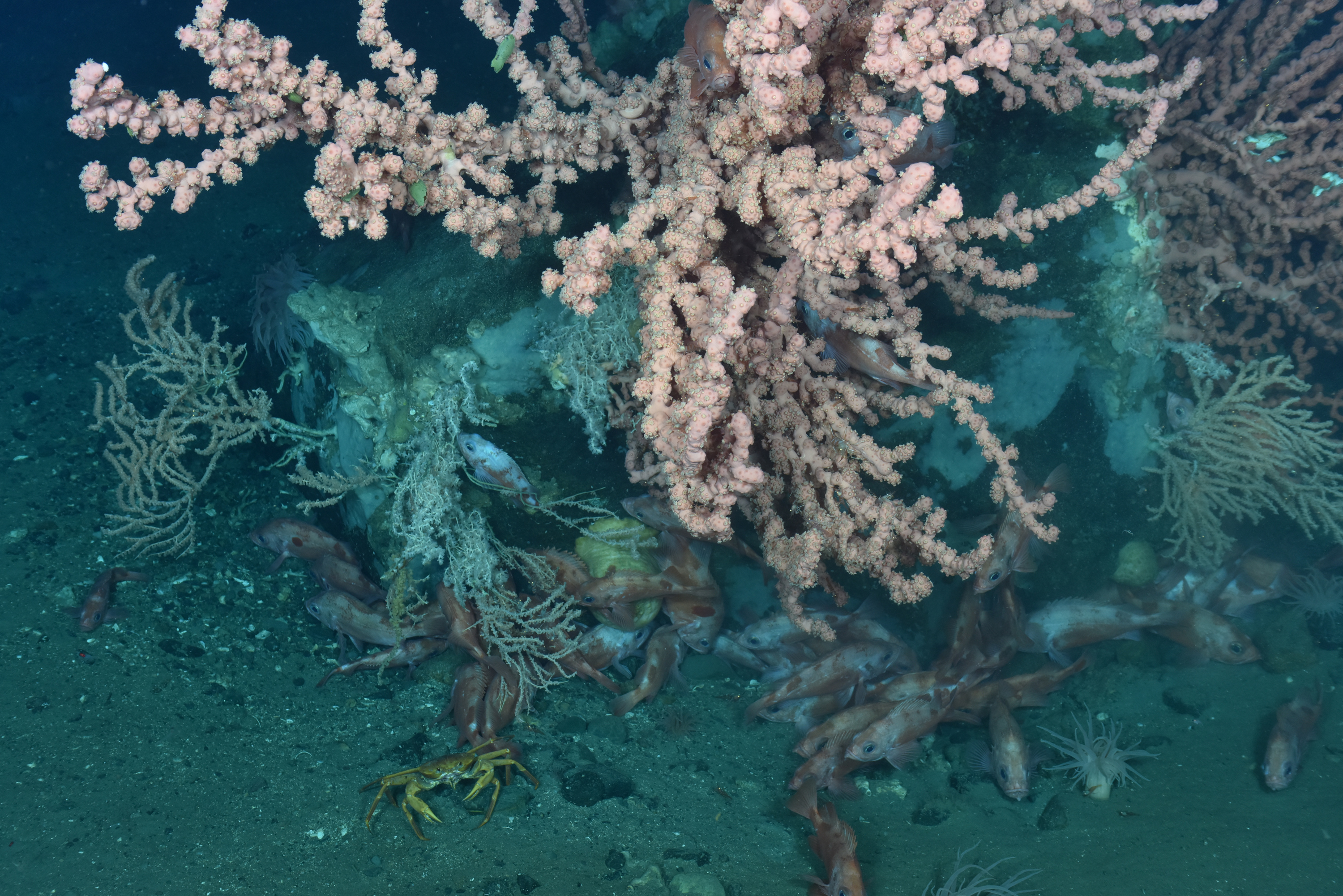
Cold-water corals at the mouth of the Fundian Channel create habitat for entire deep-sea communities.
This site also includes large areas of habitat for juvenile halibut and large, mature female lobster. The unique oceanography of the Fundian Channel makes this region highly productive. Its waters provide foraging habitat for other species including seabirds, leatherback sea turtles and blue and beaked whales. This site was proposed by Fisheries and Oceans Canada in 2018. We are part of the advisory committee for this proposed MPA and are participating fully in the site evaluation and design process.
SeaBlue Canada
SeaBlue Canada
In addition to working on specific proposed and existing MPAs in Atlantic Canada, we work at the national level with our SeaBlue Canada partners to hold the Government of Canada to account on ambitious, equitable and impactful marine protection. SeaBlue Canada is a joint project of seven of Canada’s most active and well-respected NGOs.
SeaBlue has three overarching goals that will be met collectively and through the work of individual member organizations.
-
Ensure that new protected areas meet minimum standards as committed by the federal government in April 2019.
-
Advance new protections to meet the goal of 25 per cent by 2025 and lay the groundwork for 2030.
-
Maintain and grow public support among diverse stake and rights holders for healthy ocean ecosystems.